Essential Tools of Geography explores various methods and instruments used by geographers to study the relationship between people and their environment. This resource covers fieldwork, statistical data, maps, surveying, remote sensing, GPS, and Geographic Information Systems (GIS). Each tool is explained in detail, highlighting its significance in geographical inquiry and data analysis. Ideal for students and educators in geography, this guide provides a comprehensive overview of essential geographical methodologies. Gain insights into how these tools facilitate understanding of spatial data and environmental processes.

Key Points

  • Explains the importance of fieldwork and observation in geographical studies.
  • Covers statistical data analysis and its role in understanding spatial phenomena.
  • Details various types of maps and their applications in geography.
  • Describes surveying techniques for accurate mapping and data collection.
  • Introduces remote sensing technologies, including aerial photography and satellite imagery.
  • Explains the functionality of GPS and its applications in navigation and mapping.
  • Discusses Geographic Information Systems (GIS) for data management and analysis.
newtopiccyclegrowin
3 pages
Language:English
Type:Textbook
newtopiccyclegrowin
3 pages
Language:English
Type:Textbook
265
/ 3
TOOLS OF GEOGRAPHY
1. INTRODUCTION:
Geography is the study of Earth and its people. When you study geography, you look for answers
to two major questions: How the people use Earth? How does Earth influence the way people
live? In other words, geography looks at the relationship between people and their environment-
or everything that surrounds people and affects their lives. The environment includes both living
things, such as people, plants and animals and non-living things, such as air, water and soil.
Geographical tools are used by geographers during an inquiry to acquire, process and
communicate geographical information.
2. TOOLS OF GEOGRAPHY
Following are the main tools of geography that geographers use to study and acquire
geographic information.
1. FIELDWORK AND OBSERVATION:
Fieldwork is an integral and mandatory part of the study of Geography as it facilitates an
understanding of geographical processes and geographical inquiry.
Fieldwork involves observing, measuring, collecting and recording information outside in the
field/ area of study.
Fieldwork enables to:
Acquire knowledge about environments by observing, mapping, measuring and
recording phenomena in the real world in a variety of places.
Explore geographical processes that form and transform environments.
Use a range of geographical tools to assist in the interpretation of and decision-making
about, geographical phenomena.
Locate, select organise and communicate geographical information.
Explore different perspectives on geographical issues.
2. STATISTICAL DATA AND GRAPHS:
Statistical data helps geographer to have quantitative data about certain locality/ region. The
spatial analysis of this data help study the area geographically. The data may be about the
population, soil, agriculture, height, weather or any other spatially distributed phenomena.
The results of the data are shown on graphs, charts and distribution maps.
Graphs and statistics are used to collate, organise, illustrate, summarise and compare
patterns, relationships and trends in geographical data and information.
3. MAPS/ GLOBE:
A map is a flat representation of a part of Earth. Geographers use many different types of
maps. Maps take many forms and include digital and non-digital mediums. Examples include,
but are not limited to, pictorial maps, large-scale and small-scale maps, relief maps,
choropleth maps, flowline maps, cadastral maps, isocline maps, land use maps, physical
maps, political maps, road maps, thematic maps, topographic maps and special-purpose
maps.
Maps can show lots of different information Including the location of places on the world.
Maps are used to locate, visualise, represent, display and record spatial data.
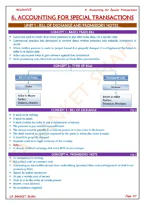
Globe is a three-dimensional scale model of a spheroid celestial body such as a planet, star,
or moon. Terrestrial globe is the globe of the Earth. Globe shows the actual reference to the
locations on Earth.
4. SURVEYING:
Generally, surveying is the systematic process of making measurements on the field from
which maps are drawn. The map is the most essential piece of equipment which the
geographer. Surveying is the science of measuring and recording distances, angles, heights
and sizes on the earth's surface to obtain data from which accurate plans and maps is made.
It is the measurement of dimensional relationships as of horizontal distances, elevations,
directions and angles on the earth's surface especially for use in locating property
boundaries, construction layout and map making.
5. REMOTE SENSING:
Generally, remote sensing refers to the activities of recording/observing/perceiving (sensing)
objects or events at far away (remote) places. in remote sensing, the sensors are not in direct
contact with the objects or events being observed.
a. Ariel Photographs:
Aerial photography is the taking of photographs of the ground from an elevated
position. Platforms for aerial photography include fixed wing aircraft, helicopters,
unmanned aerial vehicles (UAVs or drones) and balloons, etc. Mounted cameras may be
triggered remotely or automatically. Handheld photographs may be taken by a
photographer. Aerial photographs are used to take measurements of create maps and
to obtain important physical or cultural data.
b. Satellite Remote Sensing:
Satellite remote sensing is the acquisition of information on the Earth by the sensors
mounted on the satellites for this purpose. Satellite remote sensing is used in numerous
fields, including geography and most Earth Science disciplines eg. hydrology, ecology,
oceanography, glaciology and geology, it also nas military, intelligence, commercial,
economic, planning and humanitarian applications.
From satellite remote sensing, we also acquire Satellite photographs/ imageries, which
are like aerial photographs, but they are taken from space. Satellite photographs can
capture large areas of the Earth, but they can also zoom in very close.
6. GLOBAL POSITIONING SYSTEM (GPS):
The Global Positioning System (GPS) is a satellite based navigation system made up of a
network of 24 satellites placed into orbit by the U.S. Department of Defense. The Global
Positioning System is composed of 31 satellites orbiting 20,200 km above the earth. The
satellites are spaced in proit so that at any time a minimum of six satellites will be in view to
users anywhere in the world. The satellites continuously broadcast position and time data to
users throughout the world. This gives exact position anywhere on the Earth's surface. Many
countries operate their own satellite navigation systems:
United States: Global Positioning System (GPS)
Russia: Global Orbiting Navigation Satellite System (GLONASS)
China: BeiDou Navigation Satellite System (BDS)
European Union: Galileo
India: Navigation with Indian Constellation (NavIC), or
Indian Regional Navigation Satellite System (IRNSS)
Japan: Quasi-Zenith Satellite System (QZSS)
South Korea: Korean Positioning System (KPS) - under development
7. GEOGRAPHIC INFORMATION SYSTEM (GIS):
GIS is a computer-based program used to store, manage and analyses data. A GIS map is
more than a map because it can pull up a lot of information. Geographers use GIS to help
make decisions. With a GIS map, geographers can use the database (stored information) to
show where all the required phenomena are. They can then use the database to to compare
with other characteristics/ data to draw certain results and conclusions on a digital map. The
GIS helps geographers to see all kinds of information and how it relates to locations.
/ 3
End of Document
265

FAQs

What are the main tools used in geography?
The main tools of geography include fieldwork and observation, statistical data and graphs, maps and globes, surveying, remote sensing, the Global Positioning System (GPS), and Geographic Information Systems (GIS). Each tool serves a specific purpose in acquiring, processing, and communicating geographical information, enabling geographers to study and understand the relationship between people and their environment.
How does fieldwork contribute to geographical studies?
Fieldwork is essential in geography as it allows for direct observation, measurement, and recording of information in real-world settings. It helps geographers acquire knowledge about environments, explore geographical processes, and use various tools to interpret data. Fieldwork also enables the communication of geographical information and the exploration of different perspectives on geographical issues.
What is the role of remote sensing in geography?
Remote sensing involves recording and observing objects or events from a distance, using sensors that are not in direct contact with the subject. It includes aerial photography and satellite remote sensing, which capture images and data from the Earth's surface. These methods are crucial for obtaining physical and cultural data, and they have applications in various fields, including ecology, hydrology, and urban planning.
What types of maps do geographers use?
Geographers utilize various types of maps, including pictorial maps, relief maps, choropleth maps, flowline maps, and thematic maps. Each type serves different purposes, such as displaying physical features, political boundaries, or specific themes. Maps are vital for visualizing spatial data, locating places, and understanding geographical patterns.
What is the significance of Geographic Information Systems (GIS)?
Geographic Information Systems (GIS) are computer-based programs that store, manage, and analyze geographical data. GIS maps provide more than just visual representation; they allow geographers to access extensive databases to compare different phenomena and draw conclusions. This capability enhances decision-making and helps in understanding the relationships between various geographical elements.
How does the Global Positioning System (GPS) function?
The Global Positioning System (GPS) is a satellite-based navigation system composed of a network of satellites orbiting the Earth. It provides users with precise location and time data by broadcasting signals from at least six satellites visible at any given time. GPS is utilized for various applications, including navigation, mapping, and location-based services.